- People
- Safety (EHS&S)
Creating a Culture of Safety

Our team is dedicated to empowering team members with safety leadership and promoting a safe, secure and environmentally- friendly work environment in all facets of our business.
- Landowners
Find Landowner Representative in my State
 Explore making part of your land, a legacy of resiliency for future generations.
- Vendors
- Safety (EHS&S)
- Capabilities
- Our Approach
What is “Active Stewardship”?
 At RES, we don’t build sites and walk away. We design them to thrive, and stick around until they do.
- Our Approach
- Places
- Buy Credits
Buy Mitigation Credits
 Impacts are sometimes unavoidable. For these situations, we offer ecological offsets in the form of mitigation credits.
- Find Projects
Find Projects
 RES delivers resiliency, project by project. Understanding them is the best way to get to know us.
- Search States
Search by State
 Keeping the ecological balance is an intensely local endeavor. See how we meet the challenge in your area.
- Buy Credits
- About Us
- Who We Are
- Acquisitions
We are growing the RES family.
 We strengthen our team by bringing on respected teams of experts with local knowledge and experience, who share our vision of a resilient earth.
- News
- Who We Are
- Restoring at Scale

 Read the latest news about RES, our projects and our people.


Places > Five Rivers Invasives Remote Sensing
Five Rivers Invasives Remote Sensing
PROJECT SNAPSHOT
Project Type
Non-Bank ProjectLocation
Ohio | Montgomery CountySolution
Climate Adaptation & Flood Resilience, Natural Resource Planning/RestorationEcological Setting
Grasslands, Prairies, & Upland ForestsCONTACT
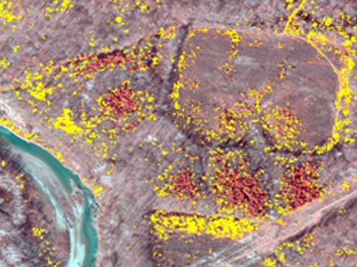
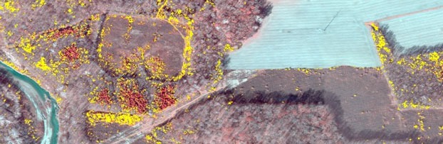
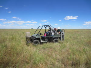
Five Rivers MetroParks in Dayton, Ohio, had been removing European buckthorn from 1,500 acres of its preserves for two years when they asked RES to map their progress, and work to be done, with strategically timed high-resolution aerial imagery.
The imagery was foundational in helping develop a habitat management plan to enhance ~15,500 acres of natural area from the ecological degradation threatened by invasive species.
To understand and prioritize strategies for future buckthorn management, RES collected aerial imagery at 6-inch resolution with our multi-spectral sensor. The flight was strategically timed in November to collect images during leaf-off tree canopy conditions while understory buckthorn still retained its green leaves.
NAIP images were also collected to enhance the image classification method, and a hierarchal object-oriented, supervised classification approach was applied to map the distribution of invasives.
Key steps in the approach were “just-in-time” image acquisition and object-based classification methods. Image segmentation methods were used to categorized image pixels into meaningful objects based on spectral signatures, image texture, and other characteristics.
Using field data, oblique imagery we collected and other data sources, RES built a model to classify and create maps of the invasive species. This project demonstrates that high resolution photography and remote sensing can be highly effective, cost-saving tools to managing invasive species.